The El Nevado de Colima hike is a beautiful hike in western Mexico, and not very touristy. So if you’re looking for an off-the-beaten-track activity in the mountains, don’t miss out on this trail!
Since it’s not super touristy, it’s not as straightforward to get to and gather information as with many more popular destinations in Mexico. But with this guide, you’ll be fully prepared for an amazing hiking adventure!
Some of the links in this post are affiliate links. This means I may earn a small commission when you click on them, at no additional cost to you. It just helps to keep this site running. I only promote products and services I really recommend and always give my honest opinion about them.
Table of Contents - El Nevado de Colima hike: Everything you need to know
Where is el Nevado de Colima
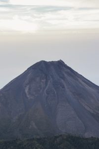
El Parque Nacional del Nevado de Colima (or the Nevado de Colima national park in English) is a national park on the border of the states Jalisco and Colima, in Central Mexico. There are 2 volcanos in this national park: Nevado de Colima (the snowy of Colima) and Volcán de Colima (which is also called El Fuego, which means The Fire). El Nevado is the volcano you can summit. El Fuego is an active volcano (even more active than Popocatépetl) and cannot be hiked. From the top of Nevado de Colima, you’ll have awesome views over El Volcán de Colima though! Which is the goal of this hike.
When to visit El Nevado de Colima
The most popular season is winter, as days are generally clearer and the top of El Nevado has snow. This makes hiking to the top trickier as well though, so you might not be able to reach the top if you don’t have the necessary equipment and experience (or a guide).
We went in mid-October which was great. No pretty snowy peaks, but we also didn’t have to walk over snow and ice. We were lucky with the weather as well. The peak of El Nevado was visible the afternoon we arrived, we had an amazing sunrise the next day and until about 1-2 p.m., the peak was still visible.
The national park is a very popular weekend destination for locals, so avoid weekends if you can. Some locals told us that on weekends in the high season, there can be about 50 tents on the campsite. I don’t think we would have enjoyed the experience as much as we did with that many people around. We arrived on a Friday and there were only 6 other people at the campsite. But when we got back from the top on Saturday, the site was already getting crowded.
Dealing with altitude el Nevado de Colima
Hiking to the top of El Nevado means hiking to 4237m, so make sure you’re acclimatized before attempting this hike. We went from Guadalajara, which lies at an altitude of about 1500m, and apart from Ciudad Valles, our previous destinations for the past month were all at altitudes of more than 1500m. So we were somewhat acclimatized. Apart from some expected shortness of breath, we felt fine.

How to get to El Nevado de Colima
You can get to the Nevado de Colima National Park by tour, with your own transport (4×4), or by public transport.
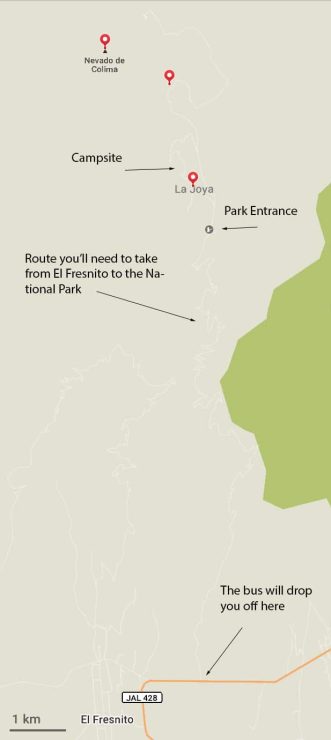
The most common ways to get here are by tour or with your own transport. If you want to go by public transport, you’ll need at least 2 days as the bus will drop you off at the bottom of the volcano. From here you’ll need to hike 1600m up over 17 km. So you’ll need one day to get to the campsite.
By Tour
There are day trips leaving from Guadalajara and Ciudad Guzmán which you can join. Contact them in advance to organize a date, because these tours don’t leave every day. Here are a few examples of agencies:
Nevado de Colima Tours seems to be the most popular one, and has the advantage of leaving from Ciudad Guzmán. This saves about 2h of driving each way to and from Guadalajara.
By car
You can rent a car in Guadalajara or Ciudad Guzmán and drive up to the campsite or even further, to Las Antenas. Driving from central Guadalajara to the park entrance takes about 3 hours. From Ciudad Guzmán it’s about an hour. It’s possible to do the whole trip in one day, but it’s a long day. If you have the time, I recommend staying the night and getting up for sunrise the next day.
If you decide to stay the night, camp at the site just after La Joya. You can park your car here as well. Hiking to the top from the campsite takes about 3 – 4 hours and you’ll need to assent another 700 meters. If this sounds like too much for you, you can also drive to Las Antenas. From here it’s about 1.5 – 2 hours of hiking to reach the top and you’ll only need to assent about 250 meters.
Accommodation Tip: Don’t have camping gear and don’t feel like sleeping in the car? You can rent a cabin for 350 pesos a night!
By public transport
This is the die-hard way. Getting to el Nevado de Colima by public transport requires a bit of planning, but the good news is that it’s definitely possible.
In order to get to El Nevado de Colima by public transport, take the earliest bus with Primera Plus from Guadalajara to Ciudad Guzmán, at 9 a.m. The bus takes 2 – 2.5 hours. At the time of writing, the first bus from Ciudad Guzmán to El Fresnito is at 12 and leaves from the same terminal. You will want to take this one as the next one is at 2 pm, which is very late to start the trek.
Ask the bus driver to drop you off at the entrance to the national park, which is just after the town of El Fresnito. This should take about 30 minutes and was 25 pesos at the time of writing.
From here it’s a 17 km hike, ascending 1600 meters, so quite a challenge. The whole hike will take about 7 hours, which is why you need an extra day for your El Nevado de Colima hike when going by public transport. Hitchhiking here is not easy, as there is hardly any traffic going up and down the road. The road only leads to the national park and the only vehicles you will come across are a few avocado farmers who have their plantations on the lower part of the volcano or people heading to the national park. The majority visiting the national park travel well-equipped and in groups, meaning cars are often full.
We managed to hitch a ride with an avocado farmer for 1 km and with other hikers for the last 2 km, saving us 3 km. We hiked the additional 14 km in about 5 hours.
Traveling with Blablacar – BlaBlaCars are frequent between Guadalajara and Ciudad Guzmán and cheaper than the bus. Just make sure to organize a ride in advance and if you book one with instant booking, confirm your trip with the driver via messaging. We’ve noticed a lot of drivers in Mexico aren’t actively checking/using the app. They just put standard trips in the app as a way of making a living. So they might not always leave, or only when enough people are signed up.
What to bring on the El Nevado de Colima Hike
- Comfortable hiking clothes and shoes. Dress in layers as in Guadalajara/at the bottom of the volcano it’s warm, but from the campsite upwards, it gets cold! Also, El Colima de Nevado weather is hard to predict, since it’s the mountains and weather changes quickly. So be prepared for all types of weather.
- A change of clothes. Make sure you have something dry to change into after your hike(s)
- Protective jacket against rain and wind
- Plenty of food. There is no restaurant/shop in the park
- Lots of water. Make sure to bring enough as it’s important to drink enough water hiking at high altitude
- Camera/phone for pictures. If you’re going without a tour or guide, make sure to download an offline hiking map like mapy.cz or maps.me on your phone too so you’ll always have access to the route map.
- Rain cover for your backpack, to protect your stuff and to make sure your change of clothes stays dry as well!
- Cash to pay your entry fee
- Hiking poles (optional)
If you’re staying overnight, also bring
- Camping gear: Tent, warm sleeping bag, camping mat
- Head torch
- Lighter/matches for campfire
If you’re going with a tour agency/guide, check with them what they will provide you and what you should bring.
At the National Park
Once you get to the entrance, you’ll pay your fee to the park ranger. At the time of writing the fee is 38 pesos per person. Camping is free. From here hike/drive just over a kilometer to reach the campsite if you’re staying overnight.
The campsite is really nice, but with minimal facilities (as to be expected with a free campsite). The toilet is pretty much a hole in the ground and there are no showers. There are a shelter, fire rings for campfires, a few tables with seats, and barbeques available though. If there is no firewood at the camp spot, ask the park ranger as they might have some for sale.
Summiting El Nevado de Colima - Available trails
There are a few options to hike to the top of Nevado de Colima. When in doubt, ask the park ranger for advice.
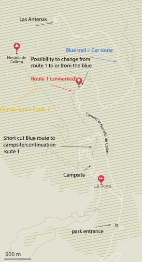
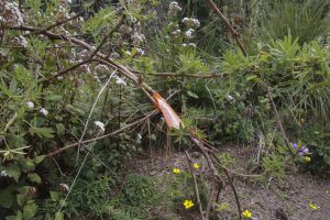
- The J-trail, marked with orange ribbons. This one is a little tricky but a very nice one.
- Route 1, is the most difficult one as it’s in fact barely a route and not marked. If you do take this one, take it coming down. Most importantly because there is a part where the route is not marked on Maps.me and there is no longer a (clear) path. Going down, you can see the next part of the path on maps.me, so you’ll know where to head to. Going up, you won’t see the path on the volcano yet when the path on Maps.me ends. Another reason is that one part is just sand/volcanic ashes so very hard to hike up. Going down is a lot easier here.
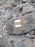
- The car route, marked with blue ribbons. This is the easiest one, but in my opinion also the least interesting. You won’t walk through the forest as much as with the other routes. But, since it’s the easiest one, if you’re not confident hiking the other trails, then this is your route. Follow it to the antennas, from where you can see the rocky part. This is where it connects to route 1 and the marks change to white and yellow lines on the rocks. This part doesn’t show up on Maps.me, but don’t worry, it is clearly marked.
Different markers along the trail

Further route recommendations
If you want the easiest route, I recommend taking the blue trail up and down. For a nice compromise between pretty and easy and in order not to take the same route up and down, take the orange trail up and the blue trail down. I recommend doing it this way and not the other way around, as the tricky bits of the orange route are even more tricky going down.
If you’re feeling adventurous and don’t want to know anything about a car route, take the orange trail up and route 1 down. As I mentioned before, route 1 isn’t much of an actual route. So give it a try if you want and if it gets too tiring, there is a point where you can connect to the blue route (see map above). Which is what we did.
Taking the blue route or route 1, you can later take a shortcut directly to the campsite. Note that this is a continuation of route 1 however, and so there is no actual path. Keep a close eye on Maps.me if you’re taking the shortcut.
Hiking up for sunrise
I highly recommend hiking up for sunrise. It was 100% worth it waking up at 3.45 am. Taking the orange trail, if you want to make sure to reach the top by sunrise, leave 3.5-4 hours before sunrise. We made it to the part where you needed to climb the rocks in 3h and watched the sunrise from there, which was also very beautiful. From about 15 min until reaching that part we had excellent views over the sunrise as well. From here we continued our way up to the top.

Hiking back to the campsite
We hiked down the other way. Following the white and yellow markers until the route splits into the blue route (towards the antennas) and route 1 (unmarked, on the other side of the canyon). We took route 1 as it looked shorter and we preferred to go more through the forest rather than walking the road for cars. The first part was fine, but afterward, the path disappeared. So we decided to cross over to the car route (blue route).

An easier hiking option – If you’re unsure about which trail to pick, or if you’re unsure this Nevado de Colima is for you, I recommend taking the blue (car) route to las antennas. The blue trail is easy and from Las Antenas you’ll already see El Volcán de Colima. Then you can decide whether or not you want to continue to the top of El Nevado de Colima. If you’re not hiking to the top, I do recommend continuing a little further, past Las Antenas. Continue on the flat path for a bit and just walk until the path turns rocky and heads up or great views.
Heading back to Ciudad Guzmán/Guadalajara
As the whole hike up and down took us about 8.5 hours, we were pretty exhausted when we got back. Luckily our fellow hikers who took us up for the last 2 km the day before, offered to take us back to Guadalajara as they were heading there as well. If we didn’t have this ride down, we would have been happy to camp another night to rest, rather than continue hiking down for a few hours. It would have been possible, but we would have been broken by the time we got down. This is why it would be good to give yourself the option to camp another night if you can take the extra weight for 2 more meals/rent a cabin for another night.
The last bus from Ciudad Guzmán to Guadalajara is at 19.30, so make sure to make your way back down in time. As we hitched a ride down, I can’t tell you from experience how long it takes to hike down. In the little information I found online, I found that it should take about 7 hours to hike down all the way from the top to the bottom of the volcano. I would calculate another hour just in case though, as it took us about 4.5 hours to hike down from the top to the campsite. We did take it easy with lots of breaks, so you can probably do it in 4. But always better to count on a little more, just in case. You’re going to want to enjoy the views and the landscape after all.
We arrived back at the campsite at about 1 p.m. ourselves and as we knew we had a ride back to Guadalajara, this was perfectly fine.
This was: El Nevado de Colima hike: Everything you need to know for an awesome experience
If you love hiking, this is an adventure you should not miss! We absolutely loved it and it’s definitely one of the best things to do when staying in Guadalajara!

Drone content on this page by Miguel Angel Alvarez
Share this:
- Click to share on Facebook (Opens in new window) Facebook
- Click to share on Pinterest (Opens in new window) Pinterest
- Click to share on WhatsApp (Opens in new window) WhatsApp
- Click to share on X (Opens in new window) X
- Click to print (Opens in new window) Print
- Click to email a link to a friend (Opens in new window) Email
